
A Unified Perspective on the Black Sea, Caspian Sea, Mediterranean Sea, and Red Sea: Their Geography and Economy
PHYSICAL GEOGRAPHY
9/10/202411 min read
The Black Sea
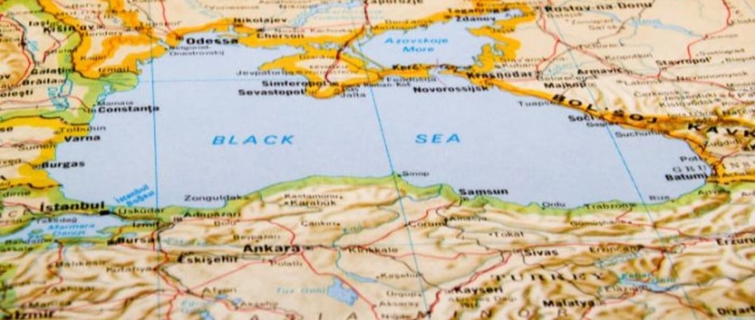
The Black Sea, an iconic body of water nestled between Europe and Asia, plays a pivotal role in the region's geography, history, and economy. Situated at the crossroads of continents and bordered by several important nations, the Black Sea has been both a gateway and a barrier for centuries.
Geographic Location and Connections
The Black Sea lies east of the Balkan Peninsula, south of the East European Plain, west of the Caucasus Mountains, and north of Anatolia. This location places it at the intersection of Europe and Asia, giving it significant geopolitical importance. To its north lies the smaller Sea of Azov, which is connected to the Black Sea by the Kerch Strait. To the south, the Bosporus Strait links the Black Sea to the Sea of Marmara, which then connects to the Aegean Sea via the Dardanelles Strait, ultimately leading to the Mediterranean Sea.
These straits are critical not just for geography, but for international trade and naval movements. The Bosporus and Dardanelles are vital chokepoints, giving countries like Turkey considerable control over access between the Black Sea and the Mediterranean. The strategic importance of these waterways has made the Black Sea a contested region throughout history, with empires and nations vying for control.
Major Rivers and Water Sources
The Black Sea is primarily fed by three major rivers: the Danube, the Dnieper, and the Dniester. These rivers provide the sea with a significant portion of its freshwater inflow, contributing to its relatively low salinity compared to other seas. The Danube, in particular, is Europe's second-longest river, flowing through ten countries before reaching the Black Sea. Its delta, a UNESCO World Heritage site, is one of the most important wetlands in Europe, supporting diverse ecosystems and wildlife.
The Dnieper and Dniester rivers, flowing from Ukraine and Moldova, respectively, also play key roles in shaping the Black Sea's hydrology. These rivers not only contribute freshwater but also transport sediments and nutrients, supporting the marine life of the region.
Countries Bordering the Black Sea
Six countries have coastlines along the Black Sea: Bulgaria, Georgia, Romania, Russia, Turkey, and Ukraine. Each of these nations has its unique historical, cultural, and economic relationship with the sea.
Bulgaria: Known for its scenic Black Sea coast, Bulgaria relies on the sea for tourism and trade. The ports of Varna and Burgas are major hubs for shipping and commerce.
Georgia: Georgia's Black Sea coast is relatively short but crucial for its economy. The port of Batumi serves as a gateway for trade between Europe and Asia, making it an important part of the region's logistics network.
Romania: The Danube River's connection to the Black Sea is vital for Romania's economy. The port city of Constanța is the largest on the Black Sea and one of Europe's key maritime centers.
Russia: Russia's Black Sea coast, including the port city of Sochi, holds significant economic and strategic value. The Russian Navy's Black Sea Fleet is headquartered in Sevastopol, Crimea, highlighting the region's military importance for Russia.
Turkey: As the country that controls the Bosporus and Dardanelles straits, Turkey holds a strategic position. Istanbul, the largest city on the sea, is not only a cultural hub but also a major economic center, benefiting from its control of the key waterways.
Ukraine: Ukraine's coast along the Black Sea is essential for its economy, with the ports of Odessa and Mykolaiv playing critical roles in trade. However, the annexation of Crimea by Russia in 2014 has significantly impacted Ukraine's maritime activities.
Ecological Importance and Environmental Challenges
The Black Sea's ecosystem is unique, with a mix of freshwater and saltwater species. However, it faces several environmental challenges. Pollution from agricultural runoff, industrial waste, and untreated sewage has led to significant degradation of the sea's water quality. Overfishing, invasive species, and habitat destruction further threaten the marine environment.
One of the most concerning issues is the formation of "dead zones" – areas with little to no oxygen due to nutrient pollution. These dead zones severely impact marine life, leading to a decline in fish populations and affecting the livelihoods of local communities that rely on fishing.
The Caspian Sea
The Caspian Sea, recognized as the world's largest inland waterbody, is often referred to as the world's largest lake, although sometimes it is considered a full-fledged sea. It is an endorheic basin, meaning that it is a closed basin with no outflow to external seas or rivers. The water in the Caspian evaporates rather than flowing outward. Geographically, the Caspian Sea is situated between Europe and Asia, giving it significant geopolitical and economic importance.
Geographic Location
The Caspian Sea is located east of the Caucasus Mountains, west of the Central Asian steppe, south of the fertile plains of Southern Russia in Eastern Europe, and north of the mountainous Iranian Plateau. This vast body of water plays a crucial role in regional trade, energy resources, and biodiversity. Its unique geography, bridging Europe and Asia, adds to its geopolitical significance, especially because of the wealth of natural resources like oil and gas beneath its surface.
Major Rivers
Several important rivers flow into the Caspian Sea, the most prominent being the Volga, Ural, and Kura rivers.
Volga River: The longest river in Europe, the Volga provides nearly 80% of the freshwater inflow into the Caspian Sea. Its vast delta is essential for Russia, both economically and ecologically, as it supports a diverse range of wildlife and sustains local communities.
Ural River: Flowing through Russia and Kazakhstan, the Ural River contributes significantly to the northern basin of the Caspian Sea. Although smaller than the Volga, its role in maintaining the northern Caspian ecosystem is vital.
Kura River: Originating in Turkey, the Kura River flows through Georgia and Azerbaijan before emptying into the southern part of the Caspian Sea. It plays an important role in supplying freshwater to the southern basin, although it contributes much less than the Volga.
Bordering Countries
The Caspian Sea is bordered by five countries, and you can easily remember them using the mnemonic RAT-KI:
Russia: Russia's northern coastline along the Caspian Sea is home to the Volga River delta and significant oil and gas resources. The region's energy extraction is critical for Russia's economy.
Azerbaijan: Azerbaijan's western coastline includes its capital, Baku, which is a major hub for oil production. The country has a long history of extracting oil from the Caspian Sea, making it central to Azerbaijan's economy.
Turkmenistan: Located on the southeastern coast, Turkmenistan relies heavily on natural gas reserves found under the Caspian Sea. This resource is a driving force behind the nation's economy.
Kazakhstan: Kazakhstan’s eastern coast, especially near the port city of Aktau, is an essential part of its oil and gas industry. The country plays a major role in regional energy production and transportation.
Iran: While Iran has the shortest coastline along the Caspian Sea, it plays a significant role in fishing, tourism, and agriculture. Iran also has claims to some of the oil and gas reserves in the southern Caspian basin.
Mediterranean Sea
The Mediterranean Sea is an intercontinental sea, uniquely positioned between three continents—Europe, Asia, and Africa—making it one of the most geopolitically significant bodies of water in the world. It acts as a bridge between diverse cultures, histories, and economies, and has been a major center for trade and civilization throughout human history.
Geographic Location and Connections
The Mediterranean Sea lies to the north of Africa, to the south of Europe, and to the west of Asia. It is connected to the Atlantic Ocean through the narrow Strait of Gibraltar, located in the far west of the sea. In the northeast, it is linked to the Black Sea via the Dardanelles Strait, creating a key waterway between the two important seas. Additionally, the Mediterranean Sea is connected to the Red Sea through the Suez Canal to the southeast, offering a vital link between Europe and Asia for international shipping and trade routes.
Bordering Countries
A total of 22 countries surround the Mediterranean Sea, each contributing to the region’s rich cultural, historical, and economic significance. You can use the following mnemonics to easily remember the countries:
European Countries (Mnemonic: Sly Fox In Malta Makes Sure Cats Bring Mice And Goats)
The European countries that border the Mediterranean Sea are:
Spain: Spain’s Mediterranean coastline is dotted with popular tourist destinations like Barcelona and Valencia, while the Balearic Islands add to its appeal as a Mediterranean nation.
France: The French Riviera is one of the most famous coastlines along the Mediterranean, known for luxury tourism and culture.
Italy: Italy, with its long Mediterranean coastline, is home to iconic cities like Rome, Naples, and Venice, as well as famous islands like Sicily and Sardinia.
Malta: An island nation located south of Italy, Malta is strategically positioned in the central Mediterranean, making it historically important for trade and military operations.
Monaco: A tiny but wealthy principality on the French Mediterranean coast, Monaco is famous for its luxury lifestyle and international events like the Monaco Grand Prix.
Slovenia: Though Slovenia has only a short coastline, it provides access to the Adriatic Sea and serves as an important link between Central Europe and the Mediterranean.
Croatia: Croatia’s Dalmatian Coast is a popular tourist destination, known for its clear waters and picturesque islands.
Bosnia and Herzegovina: Although it has a small coastline, Bosnia and Herzegovina's access to the Mediterranean via the city of Neum is vital for its trade and tourism.
Montenegro: Montenegro boasts stunning coastal towns like Kotor, with rich historical and natural beauty along its Adriatic coast.
Albania: With its rapidly growing tourism sector, Albania’s Mediterranean coast is becoming an attractive destination for travelers seeking untouched natural beauty.
Greece: Greece has an extensive Mediterranean coastline and numerous islands, including Crete and Rhodes, making it one of the most significant Mediterranean nations in terms of culture, history, and tourism.
West Asian (Middle Eastern) Countries (Mnemonic: C LIST)
The Mediterranean is also bordered by several Middle Eastern countries, which include:
Cyprus: An island country in the eastern Mediterranean, Cyprus is strategically located between Europe and Asia, with a rich cultural history influenced by both regions.
Lebanon: Lebanon’s Mediterranean coastline includes the capital, Beirut, and has been historically significant in trade and cultural exchanges between the East and West.
Israel: Israel’s Mediterranean coast is home to major cities like Tel Aviv and Haifa, making it a crucial part of the country’s economy and international relations.
Syria: Syria’s Mediterranean coast includes the port city of Latakia, an important hub for the country's economy and trade.
Turkey: Turkey has a long Mediterranean coastline that stretches from the Aegean Sea to the eastern Mediterranean, playing a key role in its tourism and geopolitical standing.
North African Countries (Mnemonic: METAL)
Five North African nations border the Mediterranean Sea:
Morocco: Though Morocco’s Mediterranean coastline is relatively small, its location near the Strait of Gibraltar makes it a key player in Mediterranean and Atlantic trade.
Egypt: Egypt’s Mediterranean coast includes the historically significant city of Alexandria, and its Suez Canal is crucial for global maritime trade.
Tunisia: Tunisia’s Mediterranean coast is central to its tourism industry, particularly in cities like Tunis and Hammamet.
Algeria: Algeria, with its extensive Mediterranean coastline, is one of the largest countries bordering the sea, and its ports are vital for trade and economic growth.
Libya: Libya’s coastline is the longest in North Africa, and its proximity to Europe makes it a key player in Mediterranean geopolitics, despite its internal conflicts.
Strategic Waterways and Economic Importance
The Mediterranean Sea's geographical position makes it a central hub for maritime trade between Europe, Asia, and Africa. The Strait of Gibraltar in the west connects the Mediterranean to the Atlantic Ocean, while the Suez Canal in the southeast is one of the most important waterways in the world, linking the Mediterranean with the Red Sea and providing a crucial shortcut for ships traveling between Europe and Asia.
In the northeast, the Dardanelles Strait connects the Mediterranean Sea with the Black Sea, further emphasizing the sea's importance as a gateway between continents. These strategic waterways have made the Mediterranean one of the busiest maritime routes in the world, vital for international trade, energy supplies, and tourism.
Red Sea
The Red Sea is a key sea inlet of the Indian Ocean, situated between the continents of Africa and Asia. This historically significant body of water has served as an essential route for trade, exploration, and cultural exchanges for thousands of years. Its strategic location, connecting the Mediterranean to the Indian Ocean, makes it a crucial passageway in global shipping routes.
Geographic Location and Connections
The Red Sea lies between northeast Africa and the Arabian Peninsula in Asia. It is connected to the Indian Ocean at its southern tip via the Bab-el-Mandeb Strait and the Gulf of Aden. The Bab-el-Mandeb Strait, often referred to as the "Gate of Grief" or "Gate of Tears," is notorious for its dangerous waters. According to an Arab legend, a catastrophic earthquake separated Arabia from the Horn of Africa, causing many to drown, which gave rise to the strait's ominous name. The Bab-el-Mandeb Strait is a narrow passage that serves as a key connection between Yemen on the Arabian Peninsula and Djibouti and Eritrea on the Horn of Africa.
To the north, the Red Sea is flanked by the Sinai Peninsula, with the Gulf of Aqaba and the Gulf of Suez extending from it. The Gulf of Suez leads to the Suez Canal, which serves as a crucial maritime route linking the Red Sea to the Mediterranean Sea. The Suez Canal is one of the most important waterways in global commerce, providing a direct shipping route between Europe and Asia without the need to circumnavigate Africa.
Countries Bordering the Red Sea
The Red Sea is bordered by six countries, which you can easily remember using the mnemonic Y SEEDS:
Yemen: Located on the eastern coast of the Red Sea, Yemen’s strategic position near the Bab-el-Mandeb Strait gives it significant importance in maritime traffic and global trade.
Saudi Arabia: To the east of the Red Sea, Saudi Arabia's coastline stretches along much of the sea's length. The kingdom uses this coast for trade and has several port cities that serve as hubs for international commerce.
Egypt: Located on the northern and western sides of the Red Sea, Egypt’s Sinai Peninsula forms the northern boundary, and the Suez Canal connects the Red Sea to the Mediterranean Sea. Egypt’s Red Sea resorts, such as Sharm El-Sheikh and Hurghada, are also major tourist destinations.
Sudan: Situated to the west of the Red Sea, Sudan's coastline is less developed than other bordering nations but still plays a crucial role in trade and regional geopolitics.
Eritrea: Eritrea’s Red Sea coast is located just north of Djibouti. Though Eritrea has faced significant economic challenges, its strategic location along the Red Sea makes it a key player in regional maritime trade.
Djibouti: Located at the southern tip of the Red Sea, Djibouti lies near the critical Bab-el-Mandeb Strait, making it a highly strategic nation for global shipping routes. Djibouti’s ports are central to international maritime traffic passing through the Red Sea and Indian Ocean.
The Red Sea Rift and Geological Significance
The Red Sea Rift underlies the Red Sea, which is part of the Great Rift Valley, one of the most geologically active regions in the world. The Great Rift Valley is a continuous geographic trench that runs from Lebanon in the Middle East to Mozambique in southeastern Africa. The Red Sea Rift is slowly widening as tectonic plates in the region move apart, a process that eventually may lead to the Red Sea expanding and becoming part of the Indian Ocean in millions of years.
This tectonic activity also contributes to the presence of geothermal features along the Red Sea’s seabed, including hydrothermal vents and volcanic activity. These geological characteristics make the Red Sea a fascinating site for scientific research, particularly in the fields of marine biology and geology.
Conclusion
The Black Sea, Caspian Sea, Mediterranean Sea, and Red Sea are four critical bodies of water that have shaped the history, economy, and geopolitics of the regions they touch. Each sea holds a unique position, whether as a crucial link between continents or as a rich source of natural resources and biodiversity.
The Black Sea, located between Europe and Asia, is fed by significant rivers like the Danube and Dnieper and has been a battleground for empires throughout history. Its connection to the Mediterranean via the Bosporus and the Dardanelles makes it vital for trade and naval movements, while its bordering nations—Russia, Turkey, Ukraine, and others—rely on it for economic and strategic reasons.
The Caspian Sea, the world’s largest inland waterbody, is an endorheic basin bordered by Russia, Kazakhstan, Turkmenistan, Iran, and Azerbaijan. Its rich oil and gas reserves make it central to global energy politics, while its unique ecosystem, particularly its sturgeon populations, highlights its ecological significance.
The Mediterranean Sea has been a cradle of civilization, connecting Europe, Asia, and Africa. Its strategic waterways, including the Strait of Gibraltar and the Suez Canal, have made it a crucial route for trade, exploration, and military endeavors for millennia. With 22 bordering nations, the Mediterranean continues to be a region of vibrant culture, tourism, and commerce.
The Red Sea, straddling Africa and Asia, is another essential maritime route, linking the Mediterranean to the Indian Ocean via the Suez Canal and Bab-el-Mandeb Strait. Its geopolitical importance is matched by its ecological richness, with its coral reefs and marine biodiversity making it one of the world’s most spectacular natural wonders.
Together, these seas form a network of global connectivity, supporting trade, biodiversity, and cultural exchange. They have been pivotal in shaping human history and continue to influence geopolitics, economics, and environmental sustainability. Understanding their roles helps grasp the broader dynamics of Eurasia and North Africa, emphasizing their lasting impact on global civilization.